
 English
 Español
 Deutsch
 日本語
日本語 Polska
 Français
 中國
中國 한국의
한국의 Українська
 Italiano
 Nederlands
 Türkçe
 Português
 Bahasa Indonesia
 Русский
 हिंदी
हिंदी


- उपलब्ध फ़ॉर्मेट्स: Cinema4D: c4d 675.68 MB
रेंडर: Standard
- बहुभुज:9 985 600
- वर्टिसिस:4 997 304
- एनिमेटेड:No
- टेक्सचर:
- रिग्ड:No
- सामग्रियां:
- लो-पॉली:No
- कलेक्शन:No
- UVW मैपिंग:
- इस्तेमाल किए गए प्लगइन्स:No
- प्रिंट के लिए तैयार:No
- 3D स्कैन:No
- एडल्ट कंटेन्ट:No
- PBR:No
- ज्यामिति:Polygonal
- खुला हुआ UVs:Unknown
- व्यूस:1689
- तिथि: 2023-07-04
- आइटम ID:453292
- रेटिंग:
Format: C4D
File size (unzipped): 571 MB
Polygons: 9 985 600
Vertices: 4 997 304
Geometry: Polygonal Tris only
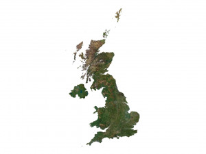
Model size: 1012.5 mm x 1750 mm x 2.571 mm
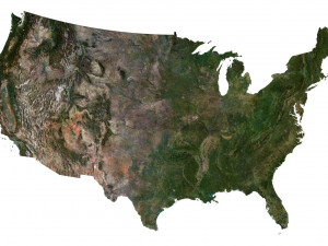
Projection: Mercator
Base: Open
UV layer: Yes (frontal)
Textures
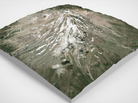
Height Map TIF 4740*8192*16b - You can use this map in the displacement channel instead of the polygonal mesh.
Normal Map TIF 4740*8192*48b - Use this map to reveal fine details of the relief.
Satellite Map TIF 8100*14000*48b
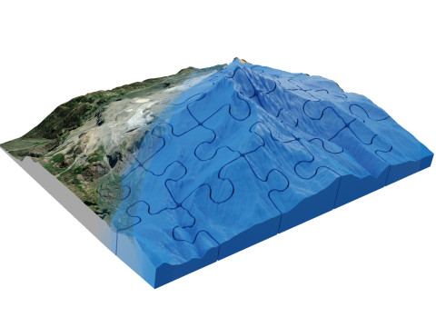
Water Mask TIF 8100*14000*48b - Use this map for masking in the Reflection channel to get glare from the water surface.
Pseudo-color Map 8100*14000*48b - Use this map to get elevation information based on the color shade.
Boundary Mask TIF 8100*14000*48b - Use this map as a mask for your background.
Other models can be made on request.
Modifications, conversion to OBJ, FBX, STL and other formats, more detailed models and better textures on request. प्रिंट के लिए तैयार: नहीं
और पढ़ेंFile size (unzipped): 571 MB
Polygons: 9 985 600
Vertices: 4 997 304
Geometry: Polygonal Tris only
Model size: 1012.5 mm x 1750 mm x 2.571 mm
Projection: Mercator
Base: Open
UV layer: Yes (frontal)
Textures
Height Map TIF 4740*8192*16b - You can use this map in the displacement channel instead of the polygonal mesh.
Normal Map TIF 4740*8192*48b - Use this map to reveal fine details of the relief.
Satellite Map TIF 8100*14000*48b
Water Mask TIF 8100*14000*48b - Use this map for masking in the Reflection channel to get glare from the water surface.
Pseudo-color Map 8100*14000*48b - Use this map to get elevation information based on the color shade.
Boundary Mask TIF 8100*14000*48b - Use this map as a mask for your background.
Other models can be made on request.
Modifications, conversion to OBJ, FBX, STL and other formats, more detailed models and better textures on request. प्रिंट के लिए तैयार: नहीं
क्या आपको और फ़ॉर्मेट्स चाहिए?
अगर आपको किसी अलग फ़ॉर्मेट की जरूरत है, तो कृपया हमें कन्वर्शन अनुरोध भेजें। हम 3D मॉडल को इसमें कन्वर्ट कर सकते हैं: .stl, .c4d, .obj, .fbx, .ma/.mb, .3ds, .3dm, .dxf/.dwg, .max. .blend, .skp, .glb. हम 3D दृश्यों को कन्वर्ट नहीं करते हैं और .step, .uges, .stp, .sldprt जैसे प्रारूप।!
अगर आपको किसी अलग फ़ॉर्मेट की जरूरत है, तो कृपया हमें कन्वर्शन अनुरोध भेजें। हम 3D मॉडल को इसमें कन्वर्ट कर सकते हैं: .stl, .c4d, .obj, .fbx, .ma/.mb, .3ds, .3dm, .dxf/.dwg, .max. .blend, .skp, .glb. हम 3D दृश्यों को कन्वर्ट नहीं करते हैं और .step, .uges, .stp, .sldprt जैसे प्रारूप।!
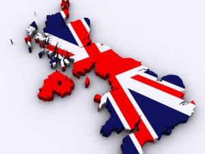
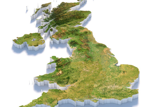
डाउनलोड करें United Kingdom Terrain 3D Map 3D मॉडल c4d से sychev23021983
united kingdom uk map landscape terrain country relief geography continent mountainइस आइटम के लिए कोई कमेंट्स नहीं है।
संबंधित आइटम्स से United Kingdom Terrain 3D Map


dae fbx mb obj stl png
deformer
Landscapes